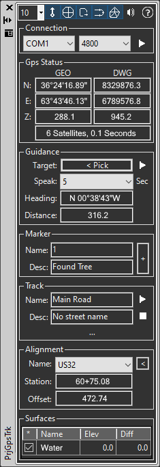
- Connect to a designated COM port with baud rate option, disconnect at any time.
- Control which portions of the dialog are visible, which keeps the dialog size down and lets you focus on the task at hand.
- Transparent command 'LGP (Last GPS Position) allows you to reference the gps position in any CAD command. For example draw a line from 'LGP to another point.
- Display of current GPS position in lat/long/meter and drawing coordinates.
- Display the number of satellites being tracked and last update time (number of seconds ago)
- Place GeoPositionMarkers at any point with a single click [+] button. Auto incrementing point name and optional description field.
- Collect paths as tracks using start, pause, and end options. Pause a track to step aside and add a point at a node, then return to the track and resume. Optional name and descriptions for each path.
- Guidance leads the user to a picked point. Optional (recommended) speech allows you to keep your eyes on where you are heading so you don't trip. Takes into account where you've been telling you if you need to bear left/right (number of degrees) along with distance to target.
- Surface difference table. As the GPS position moves (for each surface) the elevation at that location is shown along with the vertical distance from the GPS to the surface.